Tuesday, May 3, 2011

Maui Coastal Landscapes

Wai'anapanapa state park is a 122 acre park that encompasses a lovely black sand beach, dramatic sea caves, natural stone arches, hiking trails, and campgrounds. The black sand beach of Wai'anapanapa is a dangerous place to swim due to the strong currents and rocky reef.  The black sand is the result of lava flowing into the ocean and shattering when it comes into contact with the cool water of the Pacific Ocean.  The volcanic pieces are then smashed against each other and the shoreline with each wave, creating the beautiful black sand on the shoreline of Wai'anapanapa.  Make sure to bring good shoes because of the sharp volcanic rock on shore is sharp.

Wai'anapanapa Black sand beach

Sea Arch at Wai'anapanapa state park


The Ahihi cove is located inside the Ahihi-Kinau' natural area reserve, on the southern coast of Maui. It is illegal to capture fish in the reserve.  There is no sand at Ahihi cove, this area was the site of a lava flow that took place in 1790.  Lava covered everything as it poured down from Haleakala creating a moonscape type surface.  There is also seasonal high surf that create a high tide line on the shore of Ahihi-Kinau' cove. The water in the cove is fairly shallow, but there is excellent snorkeling and scuba diving activities that one can do in the cove.

Ahihi-Kinau' natural reserve

Kaihalulu known as Red Sand Beach is located on the far side of Ka'uiki Hill south of Hana bay.  The red sand beach gets its color from the crumbling of the cindercone hill that surrounds the bay. The path that leads to the beach is slippery due to the pine needles from the Iron Wood trees and the crumbling cinder. Due to seasonal high surf and strong currents, swimming is past the lava sea wall is not recommended.  Kaihalulu is also known for its nude sun bathing, it is not easy to get to you have to hike a little way.

Kaihalulu  (Red sand beach)


The Molikini crater is a sunken volcanic cindercone, that is 2 miles off the shore of southern Maui. This volcano is an erosional land form and the weathering of the volcanic sediment is eroded by wave action.  Wave breakers hit the crater and move the eroded sediment on a daily basis. The current in one direction is usually stronger then in the other resulting in a net one way transport of sediment.  Long shore drift, long shore currents, and tidal currents in combination determine the net direction of sediment transport and areas of deposit.  The result of all this weathering and erosion of the cindercone volcano, has created a fringing coral reef, where some of the best snorkeling can be done.


Molikini Crater

Molikini Crater (snorkeling trip)

Snorkeling Molikini Crater
                                                                                  
Black Rock divides the beautiful beaches of Ka'anapali and Kahekili.  Ancient Hawaiians believed that their spirits "jumped off" or left this world to join their ancestors.  This area is the sight of one of the last volcanic eruptions on Maui.  The Black Rock forms a great reef wall, and behind this wall is a cove where the water is extremely calm ( which makes for great snorkeling). The currents and waves are not that strong in the area of Black Rock.

Black Rock


Thursday, April 7, 2011

Climate, Weather, Wind and Ocean currents

Maui is a tropical island with a fairly mild year round climate tempered by the Pacific ocean, which makes the temperature stay consistent with only a few degree change.  Maui has two seasons which are summer and winter and the temperatures of summer and winter are separated by only a few degrees.  Summer is called "Kau", and takes place from May-Oct.  The average day time temperature is 85'F or 29'C, and the nights are10'F or 5'C lower than the day time. The winter months are from Nov-Apr and the winter is called Ho'oilo.  The average day time temperature is 78'F or 25.6'C and the night time temperatures are also 10'F or 5'C like the summer temperatures, which makes Maui an ideal place for vacation because of the consistency in the temperatures from summer to winter.
Due to the prevailing trade winds, most rainfall hits the north or the northeast facing shores, leaving the south and the south west areas relatively dry.  The dominance of the winds and the influence of the terrain give special character to the climate of the island.  Completely cloudless skies are extremely rare, ever though much of the cloud cover is confined to the mountain areas and the Windward slopes while the leeward lowlands have only a few scattered clouds.
Rainfall is highly variable from one year to another in Maui.  In areas where the rainfall is very high and the monthly average could exceed 10 inches, these same areas may only get 1-2 inches on the same month the very next year. Most of the rain falls on the windward slopes of the island (north, northeast) and the leeward lowlands get the remaining of the precipitation.

www.kiheivacation/maui/maui-climate/
The weather at the summit of Haleakala crater is unpredictable, the temperatures commonly range from 40'F-65'F, but can also reach below freezing at any time of the year.  Haleakala's summit is 10,023' in elevation, and if you start from the bottom of this massive volcanic crater, the temperature could be at 80'F which is the town of Kipahula and the summit could get to 30'F. As you gain altitude you can feel the air get cooler and the wind blows with more strenghth.
Haleakala is directly effected by the presence and movement of trade wind inversion, where moist surface air grades rapidly dry upper air, which gives Haleakala's climate four different climate zones.  The first zone is the marine zone which is below 3,600 ft, this zone contains moist well mixed air that comes in contact with oceanic moisture.  The next zone is the fog zone, which is approximately between 3,600ft and 5,400ft, cloud layer in frequent contact with the surface.  The transitional zone is next and this zone is betweem 5,400ft and 7,200ft, this zone has a high variable climate.  The last zone is the arid zone which is above 7,200ft, this zone is above the inversion where the air is extremely dry due to its isolation from oceanic moisture.  Several times a year major storms may deposit up to a foot of snow between Oct-May on the summit but melts because of the warmer temperatures that soon arrive after the storm.  

Haleakala volcano

Smmit of Haleakala


Kona storms are similar to cold fronts and are features of the winter storm. The rain in a well developed Kona storm is more widespread and more prolonged than in the usual cold front storm, but does not have  as strong of extreme winds as a cold front.  Kona rains can last from several hours to several days.  
On Dec 7 2007, a low pressurs system, which formed north of the Hawaiian islands caused very strong winds topping out at 50-70+ mph range, along with flooding rainfalls.  This caused property damage, downed power lines, land and mud slides and thunderstorms on all the islands, and Maui was getting the worst of it.


www.pdc.org/PDCnewswebarticles/2007/mauirainreports


Surfing is a big time activity in Maui that draws the attention of vacationers. Some of the best surfing in Maui is on the north shore, the waves can reach up to 9ft in the winter months between Nov-Feb. The reason that the northern part of Maui has bigger waves than the rest of the island is because of the wind and ocean currents that circulate through the Pacific ocean.  The N. Pacific drift is a warm current which is part of the N. Pacific Gyre that flows eastward across the N. Pacific ocean. It is a continuation of the Kuro Shio current, but doesn't extend right across the Pacific, it turns south right at about the longitude of Hawaii, which would be the northern shores of Maui.  The Subtropic Highs wind patterns are a upper air convergence and radiational cooling that causes the air to subside in the subtropics.  Subtropic Highs wind patterns are a major force behind major ocean currents.  The Westerly winds are also play a role in the ocean currents that effect the island of Maui.  The Westerly winds of the middle latitudes are winds from the west and east , bounded by jet streams and often invade the belt of the Westerlies.
Jaws is the most popular spot for big waves on Maui.  Jaws is located in Peahi, which is 3mi north of Paia. If you want to have a good time surfing surf Jaws, because there are no other waves like it on the island of Maui.

Jaws


Wednesday, March 2, 2011

Weathering and Soil

The Molokini crater is a sunken volcanic cindercone, that is off the southern shores of Maui.  Through time this volcano has become an erosional landform.  Different types of physical weathering processes such as thermal expansion / contractional cooling and salt weathering from the ocean has caused this volcano to break down and decay.  The oceans currents and wind eventually remove the weathered and eroded surface material, crating the giant crater.
Molokini crater is a very popular snorkeling destination, and I highly recommend this activity to anyone visiting the Maui. 
http://travel.ogate.com/


The IAO needle ( pronounced "EE-ow ) is a natural rock formation that is an old basaltic core, which is the remaining of a volcano.  The IAO needle is covered in lush green vegetation, and this vegetation forms pressure roots in the joints of the the rock which are also considered  fractures on this land form.  Eventually the pressure of the roots will cause biological weathering  and a slow decomposition of the IAO needle.


My wife Ely standing on the western shores of Maui, on the beach of Kapalua.  The rock formation behind my wife is basalt from lava flow. The joints on the rock were caused by thermal expansion / contractional cooling.  There is also cavernous weathering in the rock as well called Tafoni, which gives the rock a honey comb like formation.


This rock formation on Kapalua beach shows a type of physical weathering called basal weathering.  The rock is decaying around the base giving it a mushroom shape.  Salt weathering is also playing a role in the decomposition of this rock, because of the salts that are in the ocean get into the joints and cause it to decay as well.
                                                  

.

http://www.superstock.com/stock-photos.

Maui's soil is very fertile and is perfect for growing sugar cane.  Maui is a tropical region and laterization occurs within its soil producing oxisol soil, which occurs in areas with high temperatures and percipitation.  The lava that once covered the ground was rich in minerals such as iron, it has gone through oxidization since and that is what gives it that rustic color.

Monday, February 14, 2011

The formation of Maui


The island of Maui was formed by a single mantle hotspot.  This hotspot formed all the major Hawaiian islands, which are tops of giant undersea shield volcanoes.  This oceanic hotspot has created an area of uplifted topography  surrounding regional volcanism.  Underneath the earth's surface where the lithosphere is thinner, the hotspot undergoes decompression melting which results in larger swell volume and greater island building. As time goes by volcanic islands are getting older and drifting westward.  The crust upon which the volcanoes sit begins to cool, and then slowly starts to erode, this leads to the shriveling of the islands and their eventual submergence below the ocean's surface.  The hotspot is currently under the Big Island of Hawaii.


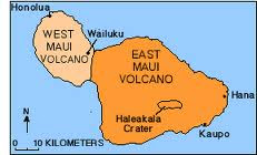
Maui has the nickname "The Valley Island" because the island was formed by 2 massive volcanoes ( The West Maui Volcano and the East Maui Volcano ).  These 2 volcanoes rose more than a mile above the ocean floor, and emitted enough lava to fill the valley between them, creating the island of Maui.
The red volcanic dirt which can be seen all over the island, is great for growing sugar cane because of the lava that came out of the volcanoes were rich in minerals, and is red in color because the lava was rich in iron, which then has since oxidized and turned rusty red.


Haleakala is the most visited part of East Maui, and is closely associated with the entire shield of east Maui Volcano.  Shield volcanoes are gently sloping mountains produced from a large number of generally very fluid lava flows.  Basalt is a type of rock that is primarily erupted from Hawaiian volcanoes.  The fluidity of molten basalt favors the formation of the lava flow, creating gentle sloping sides on the volcano.  The oldest lava flow exposed on East Maui is about  1.1 million yrs in age, which according to scientist East Maui volcano began its growth about 2 million yrs ago.


Haleakala East Volcano Shield

Wednesday, January 26, 2011

Maui's Beauty

This blog is created by John Ayala.

I chose the island of Maui as my place to explore.  Maui is the second largest island of the eight that mke up the Hawaiian Islands.

The reason I chose Maui, is because me and my new bride were married there on 10/10/10.  We said our vows in Wai' anapanapa state park, on a black sand beach with beautiful sea caves that surrounded us as well (it was like being in heaven).  We went snorkling at the Molikini Islet which is an eroded sunken volcanic cindercone, that is located 3 miles off the southern shore of Maui.  I had a chance to swim with different species of fish and observed a sea turtle swimming by as well.  I wanted to mountain bike down the Halekala summit.  This dormant volcano is 10,023 ft to its summit, and holds the record for climbing to the highest elevation in the shortest distance (38 mi).  The sun rise is also suppose to be a must see from the summit of Halekala.


                             My wife Ely and I on the black sand beach in Wai' anapanapa state park
I can,t wait to start studying this island, to see the processes it took to form these beautiful geographic features